For watersheds with sparse stream gauge data and regulatory structures (as in reservoirs), watershed modeling remains the only method available to compute discharge values—although difficult to calibrate. Statewide regression equations published by the U.S. Geological Survey cannot be applied for regulated watersheds. Without long-term stream gauge records, statistical methods cannot be applied to estimate discharges.
But now, with availability of radar rainfall data, it’s possible to develop storm rainfalls experienced within watersheds, even though the watershed lacks reliable rain gauges. Accurate rainfall data is critical input for calibration of a watershed model, and resolution of this data is critical in terms of space and time (spatio-temporal). Radar data provides spatio-temporal distribution and accuracy which is generally lacking in gauge data.
Typically, for large watersheds, and medium watersheds during fast-moving storms, variation in precipitation distribution is necessary to accomplish model calibration. With the evolution of new software programs, it’s convenient to use the radar in gridded format using HEC-HMS and other rainfall-runoff models.
Initiated under the Cooperating Technical Partner Program between the Federal Emergency Management Agency and the New York State Department of Environmental Conservation, we developed a study using radar rainfall data to calibrate East and Middle Branch Croton River watershed models. The short stream gage record available for each watershed included two summer flood events, and three winter flood events. Precipitation data necessary to calibrate the watershed model was developed using radar rainfall data.
The Solution – RADAR-based rainfall development:
The North East River Forecasting Center (NERFC) supplied GRIB files—multi-sensor precipitation estimate data, representing a day’s precipitation—for the five storm events selected for calibration.
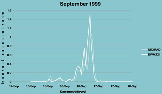
- The radar rainfall data was validated against ground-based rain gauge measurements taken at neighboring gauge stations.
- Using this data, it was possible to obtain individual rainfalls measured for each of the sub-basins, resulting in reaching calibration with minor adjustments to watershed parameters.
- The rainfall data was then converted to DSS format in order to be recognized by USACE’s HEC-HMS program used to develop the Croton River watershed models.
- Measured rainfall: rain gauge versus radar

Measured rainfall is compared using rain gauge (EWM221) and radar (NEXRAD).