Progression of HES Over the Years
Our HES consisted of several analyses that provided emergency managers and planners with the information needed to prepare, respond, and recover from a tropical storm or hurricane for potentially impacted communities. The analyses included:
- Hazards analysis: Our team investigated directional approaches rather than a one-size-fits-all approach, using the National Hurricane Center’s Sea, Lake, and Overland Surges from Hurricanes (SLOSH) model. We developed surge maps for each of the 11 counties in Georgia. This was the first time that our team published inland wind maps as a part of our hazards analysis, showing the extent of projected winds from various hurricane categories and varying forward speeds.
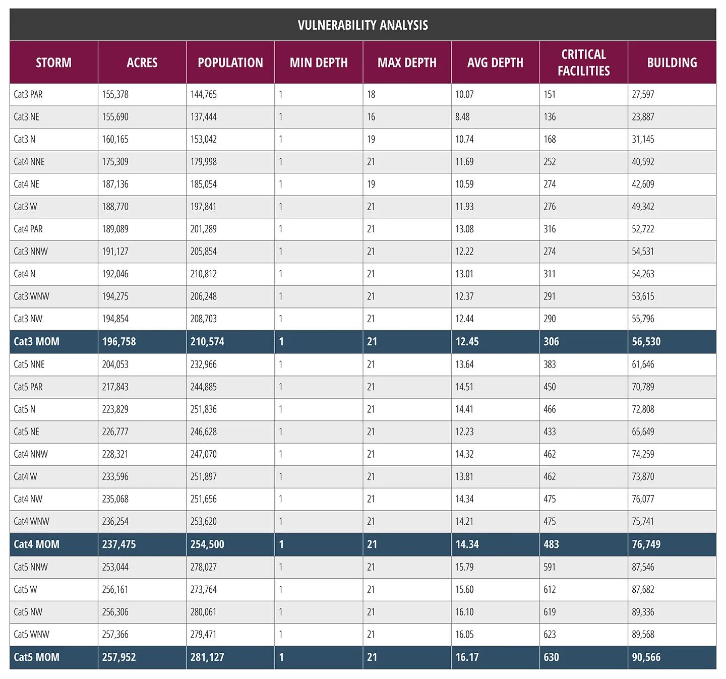
- Vulnerability analysis: A highly anticipated tool our team provided emergency officials in our HES was acreage coverage, which informs them on how many acres of land a categorized hurricane would affect. We used geospatial data that could be directly ingested into a GIS software to display the different elevations that a tropical storm could impact.
- Behavioral analysis: We explored various issues, including if the population would evacuate, where they would go, what routes they would take, if they’d seek shelter, and how many vehicles they would take. Our team conducted an analysis based on previous studies and the current population change to provide emergency officials with a range of a population number to create a plan.
- Shelter analysis: We estimated the shelter demand based on the data obtained from the behavior analysis, which concluded that the inundation extent from a tropical storm has the potential of flooding many miles inland. Our HES also concluded that no evacuation shelters will be opened in the 11 counties.
- Transportation analysis: The FEMA-recommended transportation model, Real Time Evacuation Planning Model (RtePM), used the data from earlier analyses and calculated the estimated time to get the evacuating population inland to safer locations under different scenarios. This included various storm categories; percentages of evacuating residents from Georgia, Florida, and South Carolina; and effects of a Georgia Department of Transportation mandated contraflow of Interstate16 from Savannah to Dublin. Local emergency managers will use these clearance times when deciding when to issue evacuation orders.
Once all the necessary information is gathered, the last step is to input the data into Hurrevac, a decision support tool of the National Hurricane Program. Hurrevac is administered by FEMA, with the support of USACE and the National Oceanic and Atmospheric Administration’s (NOAA) National Hurricane Center, providing program access and technical assistance for eligible users in government emergency management. This program has grown over the years, as it started as a disk operating system (DOS), transformed to Microsoft Windows, and is now an online platform. Hurrevac began in 1988 with 200 users and has now grown to over 30,000 users worldwide, covering all U.S. government locations throughout the world.
To learn more about our involvement with FEMA’s National Hurricane Program and our incorporation of technical expertise with emerging technologies to improve HES used by federal, state, and local emergency managers, check out this blog by Kevin Slover on the technology supporting the National Hurricane Program.
How to Prepare for Hurricane Threats During the 2024 Atlantic Hurricane Season
HES is critical to a community’s understanding on how to best prepare for, mitigate, respond to, and recover from a hurricane, especially now that the 2024 Atlantic hurricane season is occurring.
This year, NOAA predicted an above-normal hurricane activity in the Atlantic basin. NOAA is forecasting a range of 17 to 25 total named storms, including eight to 13 hurricanes (winds of 74 miles per hour or higher), and four to seven major hurricanes (Category 3,4, or 5 with winds of 111 miles per hour or higher).
To receive the most up-to-date information for the upcoming tropical storms and hurricanes, we recommend community members to reach out to their local emergency managers, to stay tuned with their local weather channels, and to go to the National Hurricane Center's website.